Years of working his 3,000-acre family farm in Middletown, Delaware, have impressed Robert Baker with the value of precision. To squeeze every penny from these fields of corn, wheat, and soybeans, he needs to lay down insecticide and fertilizer along exact paths. Any error eats into the profits: "If there is a gap, you get weed competition. If you overlap, you damage the crop or waste the spray."
A generation ago, his father might have posted directional flags, sprayed foam, or even hired workers to stand amid the crops like scarecrows. These days, after investing a modest $6,000 in computer software and a portable location-tracking device, Baker and his two brothers work under the guidance of radio signals from a constellation of global positioning system (GPS) satellites orbiting overhead. When the tractor is on course, a bar of lights on a dash-mounted "parallel tracking" display glow green. But if the tractor strays off track, red warning lights show up to flag the error. "With the GPS, you can make perfect swaths, so you won't overlap or go too narrow," Baker says. The system works fine even when it's too dark or foggy to see the ground.
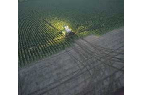
Nighttime farming is a snap, now that manufacturers routinely build GPS units into the machines.Photograph courtesy of Deere & Company
Until recently, Baker and many other small farmers viewed the promises of precision farming--using computer controls, wireless links, and GPS to take the guesswork out of growing and harvesting crops--with understandable skepticism. "Farmers have to install equipment, calibrate it, learn to make maps and to read them. That's a big adjustment," says James Lowenberg-DeBoer, director of the Site-Specific Management Center at Purdue University. Early computerized farm-management equipment was expensive and clunky. Moreover, the Department of Defense was scrambling signals from GPS satellites, limiting their resolution for civilian applications.
Now precision farming is winning over the skeptics and sparking another green revolution. The Clinton administration gave a big boost to the precision approach when it stopped GPS scrambling in May 2000. At the same time, manufacturers started building cheaper equipment and slicker, second-generation software. Farmers, who by necessity have always welcomed efficiency-enhancing technologies, quickly took notice of the growing benefits of precision. "The technology has been around for 10 years, but we didn't think that producing maps warranted getting the equipment. So we waited--the light bar is something that will actually save us money," Baker says.
He is also coming to appreciate the maps he once doubted could be useful. They are the result of another, more complicated but rapidly improving precision tool: the yield monitor, a device that compiles data on the relation between sowing and harvesting. Baker can easily pop the small white GPS receiver off the roof of his tractor and attach it to his Case International combine. Then as he moves through the field, a computer and set of sensors on the combine gather information on everything from local weather conditions to the abundance of nutrients in the soil. A screen inside the combine, resembling an oversize PalmPilot, displays the data in graphic form, helping Baker pinpoint trouble spots. "It helps you make management decisions," he says. "You can see which seed varieties produced 150 bushels of corn [per acre], for instance." He can correlate performance with other variables, such as soil acidity. He can even compare his results with maps from other precision farms.
Despite these benefits, Lei Tian, director of the new Illinois Laboratory for Agricultural Remote Sensing, thinks the technology could do a lot better. He is developing upgraded mapping programs that will provide far more detailed analyses of how crops are faring. Someday he expects farmers will "seed" their fields with tiny sensors that will continuously monitor soil conditions to keep those maps current and complete.
For a really big-picture view, some farmers are already starting to merge precision farming with high-resolution imagery from airplanes or satellites. Jay Parrish, the former director of the Geographic Information Systems department in Lancaster County, Pennsylvania, coaxed along the process by initiating a reference catalog of Landsat snapshots of every farm in his county. These images will be posted on a Web site and updated as they are available. Comparison views of the Earth in visible light and infrared can reveal where plants are growing well and where they are stressed. "We are looking at biomass--how much vegetation there is, how healthy it is. Now a farmer can compare his farm to one down the road," Parrish says. The project is funded with a $25,000 grant from NASA, which is supporting similar efforts around the country.
The influx of technology makes farming not only more efficient but also more environmentally benign. GPS-guided tractors mean less waste of fertilizer, pesticides, and herbicides. Satellite images and yield-monitor maps show which areas are producing poorly, allowing farmers to apply chemicals only where they are truly needed. Combined with high-accuracy spraying, these advances could significantly reduce the use of groundwater contaminants. "The current practice is to spray everything. If you can concentrate the insecticide and herbicide application, there's a potential to save money and benefit the environment at the same time," says Lowenberg-DeBoer.
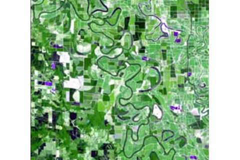
This Landsat 7 view of the Mississippi Valley has been processed to help farmers track land-use patterns.
Photograph courtesy of USGS
Precision farming could also reduce concerns about genetically modified crops, or at least make them a bit more manageable. Farm-equipment manufacturer John Deere has developed the CropTracer System to keep track of seeds over their entire life cycle. Before planting the crop, a farmer scans a bar code on a bag of seed to identify what is about to go into the ground. CropTracer, a mix of GPS and database, then notes when and where the seeds are planted, how much and how often they are sprayed, and finally when and where they are harvested. Such detailed record keeping should make it much easier to separate modified crops from unmodified ones and prevent a repeat of the StarLink fiasco, in which bioengineered corn intended as animal feed turned up in snack foods, prompting a costly recall.
In the long run, precision technologies seem sure to eliminate one of the quintessential images of agriculture, the farmer riding a tractor through the field. GPS-guided signal lights are already built into many new tractors and manure spreaders. During the past five years, Bradford Parkinson, a GPS pioneer at Stanford University's W. W. Hansen Experimental Physics Lab, has worked with John Deere to create an autonomous tractor that could reliably carry out preprogrammed movements in fog or at night. In test runs, the tractor worked well even when operated without a driver. "The issue is whether OSHA will allow farmers to do that," he says.
Michael O'Connor, one of Parkinson's students on the autonomous tractor project, is confident they soon will. As director of engineering at Integri-Nautics of Menlo Park, California, he has created Autofarm, a $45,000 GPS-based navigation system that can steer a tractor with one-inch accuracy. The company requires that a person ride along, but touts Autofarm as a "hands-free system," meaning the driver is there mainly for show. And what about a fully automated machine? "It will take a lot of R&D to make it safe and cost effective," O'Connor says. "Five years is probably the right ballpark." New Holland, a farm equipment manufacturer in New Holland, Pennsylvania, has already built an autonomous baler in collaboration with NASA and Carnegie Mellon University. In test runs, the baler successfully harvested a 100-acre alfalfa hayfield in California with no human guidance.
When the equipment is perfected, Baker will be happy to let a computer do the driving. "The American public has a romanticized dream of what life is like on a farm," he says. "Six hundred hours on a combine is not glamorous. I'm all for anything that makes it easier."

For a look at how researchers are making satellite imagery available to farmers, visit the University of Arkansas's RAPID project (www.cast.uark.edu/cast/rapid/index.html), the remote-sensing program at the University of Illinois (www.age.uiuc.edu/ remote-sensing/Sensing.html), or the site-specific management center at Purdue University (mollisol.agry.purdue.edu/SSMC).
The DEMETER project (www.rec.ri.cmu.edu/projects/demeter) built the automatic hay baler. IntegriNautics (www.integrinautics.com) and John Deere (www.deere.com) have lots of commercially oriented precision-farming information on their Web sites.


