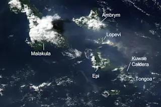
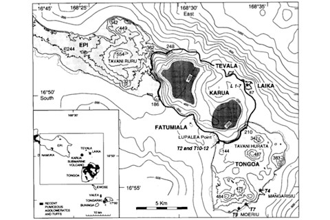
If you read this blog regularly, you know I have a fondness for the so-called "missing eruptions" -- that is, volcanic events found in ice core or sediment records but not yet identified in the geologic/volcanic record. The most glaring right now is the eruption of 1258 A.D., supposedly 1.8 times as large as the 1815 eruption of Tambora, but no candidate volcano has been conclusively identified as the source. Another enigmatic climate event that has a little more potential to be matched with a volcano happened during the mid-1450s, a period that saw cold winters in China, dry fogs in Constantinople and stunted tree ring growth around the world. It also saw one of the biggest cases of sulfur loading in the atmosphere in the last few thousand years, rivaling that of the famous 1783 Laki eruption in Iceland. All these climatic effects have been attributed to an eruption in the New Hebrides arc, specifically the Kuwae caldera in Vanuatu. However, the relationship between this eruption at the climate signatures -- and the existence of the eruption itself -- is still hotly debated. The Kuwae caldera is located between Epi and Tongoa islands in Vanuatu (see below). The volcanic arc, called the New Hebrides arc, is home to a number of more famous volcanoes, such as Yasur, Gaua and Ambrym. Here, the Australian plate is subducting under the New Hebrides microplate producing mainly basaltic island arc volcanoes. However, a few of these volcanoes have produced explosive caldera-forming eruptions. The Kuwae caldera sits in between two islands that were once connected into a larger island, but today a roughly 12- by 6-kilometer depression separates Epi from Tangoa. Looking at the volcanic record, multiple generations of activity are centered around the depression, including hydromagmatic basaltic eruptions, some large dacite pyroclastic flows and a welded dacite tuff. On the northeast side of the depression sits a small basaltic cone (~ 1 km^3) called Karua and it represents the recent volcanism between Epi and Tongoa, mostly small submarine eruptions that formed ephemeral islands.
Now, thanks to its submarine location, it is hard to closely examine the Kuwae depression to determine its origin, so geologists have used a variety of clues to deduce how it may have formed. Interestingly, one of the primary sources of information is anthropologic -- folklore in the region. Stories exist of the destruction of Kuwae Island, where the land felt strong earthquakes, tsunamis inundated the neighboring islands and the island itself tilted and collapsed during a great eruption. Some people living on the island died, but many were able to flee to Efate island to the south before the island disappeared. These people were able to resettle the now-separate Tongoa Island with six years of the dramatic events. Although this folkloric record is tantalizing, using it to date the event is tricky -- early attempts using generational data put the eruption in the 1540-to-1654 range. However, later radioisotope dating has proven that is too recent. Even the interpretation of the tales is controversial; the location of the missing island could be to the south of the present-day Tongoa, rather than to the north. The geologic record is as difficult to interpret. Although there are clearly volcanic deposits related to an eruption present, the only dating technique that can be applied is ^14C (radiocarbon), which can provide an approximate age, but assumptions about when the trees died (during the eruption?) leave the age open to some interpretation. Currently, the most refined ^14C age for the Kuwae event is ~1452 A.D., but dates range from the 1420s to the late 1450s. The ice core record offers some circumstantial evidence of a large eruption in ~1455 to 1458 A.D. that, in a somewhat circular sense, has been attributed to Kuwae and used to define the age of the eruption. Even in high-resolution dating of ice cores, the range of ages when comparing with other cores might be 1 to 3 years and the lag between an eruptive event and its inclusion in the ice core record can range from 0.6 to 2.5 years. Along with that, global climatic effects were observed in the middle 1453-1454, including "non-stop snow" in China, consisting of 40 days of snow south of the Yangtze River and a dry fog in Turkey during April and May 1453. The tree ring record shows stunted growth in North America, Europe and Asia during 1453-1457 as well. However, we are still stuck with the conundrum that we can't fix a date on Kuwae that is independent of the circumstantial evidence offered by ice cores and climate records. So, what might have happened at Kuwae during the 1450s? This is controversial as well. Work by Monzier and others (1994) and Robin and others (1994) claim that an eruption that produced ~32 to 39 km^3 of erupted material occurred at Kuwae, where a caldera was produced that separated Epi from Tongoa. The caldera floor itself dropped anywhere from 650 to 1,100 meters and its overall size put it as the 7^th largest caldera eruption in the last 10,000 years -- on the same scale as the Minoan eruption of Santorini and the eruption that formed Crater Lake in Oregon. Using estimates of erupted volume (which is difficult as much of the material may have been deposited at sea), the magnitude of the eruption might have been ~6.9 to 7.2 (which corresponds to VEI 7). Prior to the caldera-forming eruption, the area had one or possibly two smaller volcanoes that were destroyed during the 1452 eruption, which may have lasted only a few days. However, activity leading up to and following the climactic eruption may have lasted months to years. It is clear that the type of magma that erupted from Kuwae changed from basaltic andesite prior to the caldera-forming event to dacite to rhyodacitic during the event (and now back to basaltic andesite) -- however, the trigger of the eruption is not resolved either. It might have been triggered by magma-water interaction during the eruptions that lead up to the caldera forming or it might have been caused by mixing of magmas just prior to the 1452 eruption. However, work by Nemeth and others (2007) claims that there was no giant eruption at Kuwae. They point out the lack of substantial deposits on islands near the supposed caldera, sometimes as little as 10 cm of ash within a few kilometers of the source. They suggest that what is preserved represents localized pyroclastic flows and mainly submarine eruptions that could not have had a strong effect on global climate as no large (>25 km) eruptive plume would have been produced. They also point to the fact that the islands were resettled very quickly after the eruption. They even suggest that the caldera itself might represent multiple smaller events, a much older caldera eruption or even a caldera formed during an almost wholly submarine eruption. A study by Plummer and others (2012) from this year that looked at the Law Dome ice core record from Antarctica even suggests that the sulfur spike seen in the 1450s may be two eruptions, one in 1453 and a larger one in 1458. They say that care must be taken in attributing the sulfur spike and climate effects in the 1450s to Kuwae as the data is far from conclusive that they are linked. So, quite a puzzler, isn't it? There is clearly at least one, possibly two, large volcanic events that dump over 100 megatons of H2SO4 into the atmosphere and potentially have altered global climate for a number of years. The one supposed "smoking gun" for this event, the Kuwae caldera, may or may not have even been a large eruption and the date of the eruption(s) is still very much in the air. Unlike other large caldera-forming eruptions that have occurred in the last 10,000 years, the submarine location of the Kuwae caldera makes studying the events much more difficult. This isn't like the ~7,700-years-before-present Mazama eruption at Crater Lake where you can go and sample all the deposits on land, find the ash layers across the landscape and pick it apart. At Kuwae, we have bits and pieces of tantalizing evidence that paint a very incomplete picture and hidden in that picture might be a massive eruption ... or it might be just distracting us from finding the real culprit. References:
Monzier, M. and others, 1994. Kuwae (~1425 A.D.): the forgotten caldera. Journal of Volcanology and Geothermal Research, 59, pp 207-218.
Nemeth, K. and others, 2007. Kuwae Caldera and Climate Confusion. The Open Geology Journal, 1, pp 7-11.
Plummer, C.T. and others, 2012. An independently dated 200o-yr volcanic record from Law Dome, East Antarctica, including a new perspective on the dating of the c. 1450s eruption of Kuwae, Vanuatu. Climate of the Past Discussions, 8, pp. 1567-1590.
Robin, C. and others, 1994. Formation of the mid-fifteenth century Kuwae caldera (Vanuatu) by an initial hydroclastic and subsequent ignimbritic eruption. Bulletin of Volcanology, 56, pp. 170-183.
Witter, J.B. and Self, S., 2007. The Kuwae (Vanuatu) eruption of AD 1452: potential magnitude and volatile release. Bulletin of Volcanology, 69, pp. 301-318.
Image 1: Kuwae caldera in Vanuatu. Image from NASA EO. Image 2: Map of Kuwae caldera. From Monzier et al., 1994.


