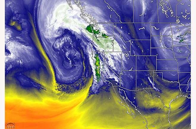
The Pacific Ocean's now-notorious "bomb" cyclone allied with a wavy jet stream — and amped up by climate change — have aimed a river of moisture at California, causing deadly torrents of precipitation and a battering by ferocious winds.
A similar atmospheric river event in late December may have conveyed more than 220 million pounds of water through the atmosphere over the Pacific Coast every second, according to Washington Post meteorologist Matthew Cappucci. The current storm may have approached that intensity.
It has already claimed two lives, including a young child, and as of Thursday morning, Jan. 5, it was blasting the coast of California with hurricane-force winds along with continued rain, according to CNN. Almost all of the state's population is under a flood watch.
Satellite images are one way to appreciate the enormous scope and power of this storm. The image at the top of this post combines an infrared view from the GOES-18 satellite with NEXRAD radar data to provide a compelling visual that shows water vapor in the atmosphere and the rate of rainfall. (The latter is rendered in green and yellow tones.)
That still visual is one frame from an animation showing the swirling storm and its impact:
The animation starts at 10:30 a.m. local time on the West Coast and ends at the same time today (Thursday, Jan. 5). Once again, the view shows water vapor in the atmosphere and a radar view of precipitation.
This animation of GOES-18 imagery provides a broader view of the bomb cyclone as it helped direct the atmospheric river of moisture toward the Pacific Coast. It starts at 4 p.m. local time on Tuesday, Jan. 3 and runs until 12 p.m. on Wednesday.
By my rough estimate, the cyclone stretched across at least 1,400 miles of the Pacific. That's roughly equal to the distance between Los Angeles and Omaha!
As it has evolved, the cyclone has been carried across the Pacific by the jet stream. Big southward dips in that high altitude river of air have allowed storms to pick up copious moisture in the subtropics.
As meteorologist Ryan Made told the Associated Press, "I’d describe the jet stream and bomb cyclones as a runaway Pacific freight train loaded with moisture. Climate change adds more fuel to the locomotive engine.”
Yet another storm is on the way this weekend.

