
Volcanologists can't predict eruptions. There is no reliable and tested method that can say that a certain volcano will erupt on a certain day or at a certain time. You might see such things on YouTube and elsewhere on the internet, but they are mostly people making patterns where there are none.
However, volcanologists have been getting much better at forecasting eruption likelihood. Now, that might sound a lot like prediction, but it is not. Instead, it is like the weather: they can offer the chances that an eruption might occur over some time period, like a meteorologist might say that we have a 75% chance of a thunderstorm this afternoon. These volcanic forecasts might only be days or hours in advance on an eruption, but even that little warning means getting out of harm's way.
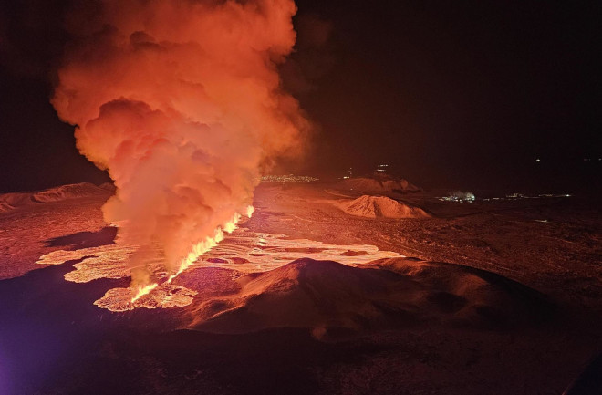
The numerous eruptions over the past few years on the Reykjanes Peninsula in Iceland has been an opportunity for volcanologists to really dig into the signs that an eruption is imminent. There are a bevy of measurements that are being made in the area, including gas emissions, land surface motion in three dimensions, earthquake activity and thermal emissions. All of these give us insight into what the magma lurking beneath the surface might be doing.
The Icelandic Meteorological Office (IMO), the agency in charge of monitoring volcanoes on the island nation, had this to say about the current state of things near Grindavík on February 29:
Considering precursors of previous volcanic eruption in the Sundhnúkar crater row, likelihood of a volcanic eruption increases once the volume of magma reaches 8 – 13 million cubic metres. If magma accumulation continues at the same rate, the amount should reach the upper limit next week.
So, how do they know this? Much of it comes from taking GPS data of how the land is moving in the area, both up and down and side to side, and modeling how much magma it might take to cause those changes (see below).
Like any idea, it involves assumptions and needs some other sources of data. Earthquakes can give you an idea of just how deep the magma might be. This is because as it fills in the crust as it rises from its source in the Earth's mantle, it causes earthquakes as it cracks the rock surrounding it. These earthquakes can then be triangulated by multiple seismometers and the depth they occurred is calculated. It can also offer some insight into the shape of the intrusion of magma. In this case, it looks like a narrow, linear feature.
Take these data (ground deformation and earthquakes) along with assumptions about how the rock type in the area responds to stress and you can estimate just how much magma is accumulating. Right now the IMO estimates that magma is accumulating under the area at about 0.5 million cubic meters per day. Roughly speaking, that is about 1.5 oil supertankers of magma every 24 hours.
Tracking the deformation since the last eruption, the IMO estimates we're very close to reaching the threshold were an eruption becomes very likely. When the threshold is reached (at least during previous eruptions), the magma then moves rapidly to the surface with as little as 30 minutes warning after the earthquakes associated with that rise start. Then, boom, with have another fissure opening with lava fountains and lava flows.
The location of the deformation right now suggests to the IMO that the eruption is likely to start between Mt. Stóra-Skógfell and Mt. Hagafell. This puts it between the January eruptions on the outskirts of Grindavík and the eruptions earlier in February closer to the Blue Lagoon.
The IMO has put together some maps that show where lava could end up if an eruption occurs in this region. This is based on how the lava behaved during previous eruptions and the rates at which lava erupted during those events as well. A more southerly eruption (above) might put the outskirts of Grindavík back in the path of the eruption while a more northerly location (below) will impact the roads and infrastructure related to the geothermal plant near the Blue Lagoon. These are just model scenarios, but at least give hazard planners some inkling about what could be in harms way.
For all of this, more information is better. This could help defuse many of the rumors and speculation in the media and internet that tends to come hand in hand with a volcanic crisis. It also allows for better protection of life and property when the next eruption occurs. Hopefully these data from Iceland can be applied to other volcanoes around the planet to continue reducing the deaths and injuries from eruptions.


