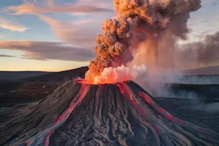
Iceland's Reykjanes Peninsula has cracked open again, creating a nearly 2-mile-long volcanic dyke that has allowed lava to shoot up as high as a 20-story building.
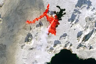
The Feb. 8 eruption sent molten rock sluicing across a snow-covered landscape. This has made for some dramatic views from space, as seen above in an image acquired by one of the Sentinel-2 satellites, and in this one captured by Landsat-9 on Feb. 10:
In natural color views, the lava is faint — if it's visible at all. But in the infrared, it burns brightly. So to create this compelling image, visible and infrared data were combined.
Continuing Volcanic Unrest
This is the third eruption on the Reykjanes Peninsula since December. The remains of the second one, which occurred in January, can be seen to the south and a little east of the current event. Here, lingering warmth seems to have prevented any snow from sticking, so the area appears black.
Luckily, the lay of the land around the new fissure channeled most of the fresh lava into an unpopulated area to the east. This spared the town of Grindavík to the south. Even so, some lava did flow west toward a power plant and the Blue Lagoon, a famous geothermal spa. Defensive walls fended off the flow, but the molten rock did cut a hot water pipeline and two roads.
New lava stopped pouring from the fissure on Feb. 9, and no volcanic tremors were continuing. "This suggests that the eruption is ending," according to a Feb. 12 update from the Icelandic Met Office. But another one seems likely.
Land is rising at rate of about 0.5 to 1.0 centimeters per day in the area around Svartsengi, home of the Blue Lagoon and the power plant. "Magma thus continues to accumulate in the magma reservoir beneath Svartsengi," according to the Feb. 12 update. "It is therefore highly likely that the cycle continues in a few weeks with another dyke propagation and a volcanic eruption."