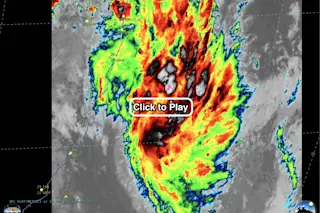
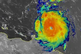
Infrared imagery from the GOES-16 weather satellite shows the formation of Tropical Storm Iba off the east coast of Brazil at 16 UTC on March 24, 2019. (Note: This is a big file, so after you click on the screenshot, the animation may take a little while to load. Source: Cooperative Institute for Meteorological Satellite Studies) For the first time since 2010, a full-fledged tropical cyclone has formed in the South Atlantic Ocean. Say hello to Tropical Storm Iba. You can see it in the animation above, about 500 miles northeast of Rio de Janeiro, Brazil. The animation consists of infrared imagery from the GOES-16 weather satellite. It shows Iba as it strengthened on Sunday. The false colors correspond to the temperature of the cloud tops in the storm, with black and pinkish colors indicative of the very coldest temperatures. (And at -90 C, or -130 F, in some pink ...
Tropical Storm Iba has formed off the Brazilian coast — a real rarity in this part of the world
Tropical Storm Iba forms in the South Atlantic Ocean, marking a rare event observed via GOES-16 weather satellite's infrared imagery.
More on Discover
Stay Curious
SubscribeTo The Magazine
Save up to 40% off the cover price when you subscribe to Discover magazine.
Subscribe

