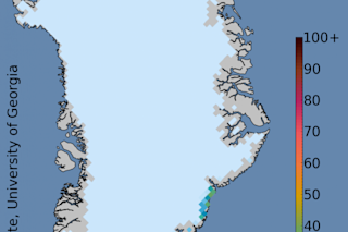
This Greenland cumulative melt days map shows the total number of days that surface melting has occurred for the year to date. (Image: National Snow and Ice Data Center Greenland Ice Sheet Today) Update: I've been in touch with Ted Scambos of NSIDC. He corrected me on one fact that I misunderstood, and he added some new information about the significance of this event. See below. (I've also changed the headline.) As the map above shows, some portions of Greenland's ice sheet have experienced melting at the surface for more than 30 days since the first of the year. And at least through the end of last week, the melting, as revealed by satellite data from the Defense Meteorological Satellite Program, had been continuing. It's not just wet snow. What's being observed is wet snow. Even so, it is "real melting," Ted Scambos, Senior Research Scientist with the National Snow ...
Snow in Greenland is melting — in winter
The Greenland ice sheet melting raises concerns about rising sea levels amid increasing surface melt days this winter.
More on Discover
Stay Curious
SubscribeTo The Magazine
Save up to 40% off the cover price when you subscribe to Discover magazine.
Subscribe

